Geographic Data

- The Town of Kamenice nad Lipou is located at 49°15' of latitude north and 15°04' of longitude east, 561 m of altitude (ranging from 520 to 600 metres above sea level)
- The town is located just in the middle between Pelhřimov and Jindřichův Hradec on the road E551, or it can be reached by train from Jindřichův Hradec or Obrataň.
- Before the administration incorporation in Pelhřimov District in 1960, Kamenice n.L. was a district town for more than five decades; after that, Pelhřimov became the district town. Pelhřimov District is located in the Bohemian-Moravian Highlands and it belongs to Vysočina Region. The town also includes Antonka, Gabriela, Johanka, Nová Ves, Březí and Pravíkov settlements. The total population along with the local parts is around 4200.
- Kamenice nad Lipou is dominated by Melíšek (605 metres above sea level), the hill where silver was mined in the years 1720-1736 and 1780-1833, and Antonka (664 metres). The highest hills in the vicinity are Pečecký (718 metres), Eustach (710 metres) and Troják (704 metres).
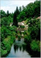
- The area is that of springs, with an average yearly sum of precipitation 677 mm. The distance of the springs of the Kamenice River running through the town and its tributaries from the town is not longer than 7 km. They converge in a fan-shaped manner from the west, north and east to leave the town to the south where, after its confluence with Žirovnice, it forms the well-known Nežárka River.
- Geologically, the area is formed by Moldanubic sediments, cordierite gneiss covered by sand sediments in valleys.
|